


The ancient Mesopotamians created a massive, sophisticated network of canals to water their crops more than 3,000 years ago, a new study has revealed.
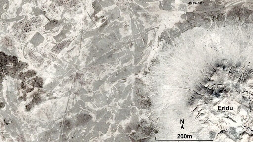
Researchers found thousands of ancient irrigation canals up to 5.6 miles (9 kilometers) long carved into the landscape near Basra in Iraq, which at the time was the Eridu region of Mesopotamia. Mesopotamians occupied this region along the vast Euphrates river from the sixth millennium B.C. (8,000 to 7,000 years ago) to the early first millennium B.C. (3,000 to 2,000 years ago).
The canals provide researchers with rare insights into the ancient practices of Mesopotamians, according to a statement released by Durham University in the U.K., one of the universities involved in the research.
“This ground-breaking discovery not only enhances our understanding of ancient irrigation systems but also highlights the ingenuity and adaptability of early farmers,” Durham University said in the statement.
The researchers published their findings Feb. 18 in the journal Antiquity.
Related: What’s the world’s oldest civilization?
Mesopotamia was a historical region that included parts of modern-day Iraq, Syria, Turkey, Iran and Kuwait. “Mesopotamia” is an ancient Greek word that can be translated to “the land between two rivers.” Those rivers were the Tigris and the Euphrates, which flowed from eastern Turkey to the Persian Gulf.
Along the Euphrates river was Ancient Babylon, which sat at the heart of the Mesopotamian civilization around 2000 B.C. to 540 B.C., and the even more ancient city of Eridu, founded closer to the Persian Gulf around 5,400 B.C. The newly discovered canals were carved out of the sides of the Euphrates and supplied farms in the Eridu region. That was until the river shifted course, drying out the region and leaving the canal trenches behind, according to the study.
“A shift in the ancient course of the Euphrates River left this region dry and consequently unoccupied after the early first millennium BC until now,” the study authors wrote. “This has allowed the archaeological landscape of this region to remain intact and thus we were able to identify and map a vast, intensive and well-developed network of irrigation canals that pre-date the early first millennium BC.”
The researchers traced these canals using satellite imagery, geological maps, drone footage and other techniques. In total, they found more than 200 primary and secondary canals and more than 4,000 smaller canals connected to the main channels. They also identified more than 700 farms, which typically had small canals around their perimeters, according to the study.
The study authors noted that though the network is vast, the canals were probably not in use at the same time.
“This reconstructed network of irrigation canals represents the combined agricultural activities for all the periods of occupation in the region and it is unlikely that all of the canals were running simultaneously during the entire occupation period (i.e. from the sixth until the early first millennium BC),” the study authors wrote.
Premium IPTV Experience with line4k
Experience the ultimate entertainment with our premium IPTV service. Watch your favorite channels, movies, and sports events in stunning 4K quality. Enjoy seamless streaming with zero buffering and access to over 10,000+ channels worldwide.